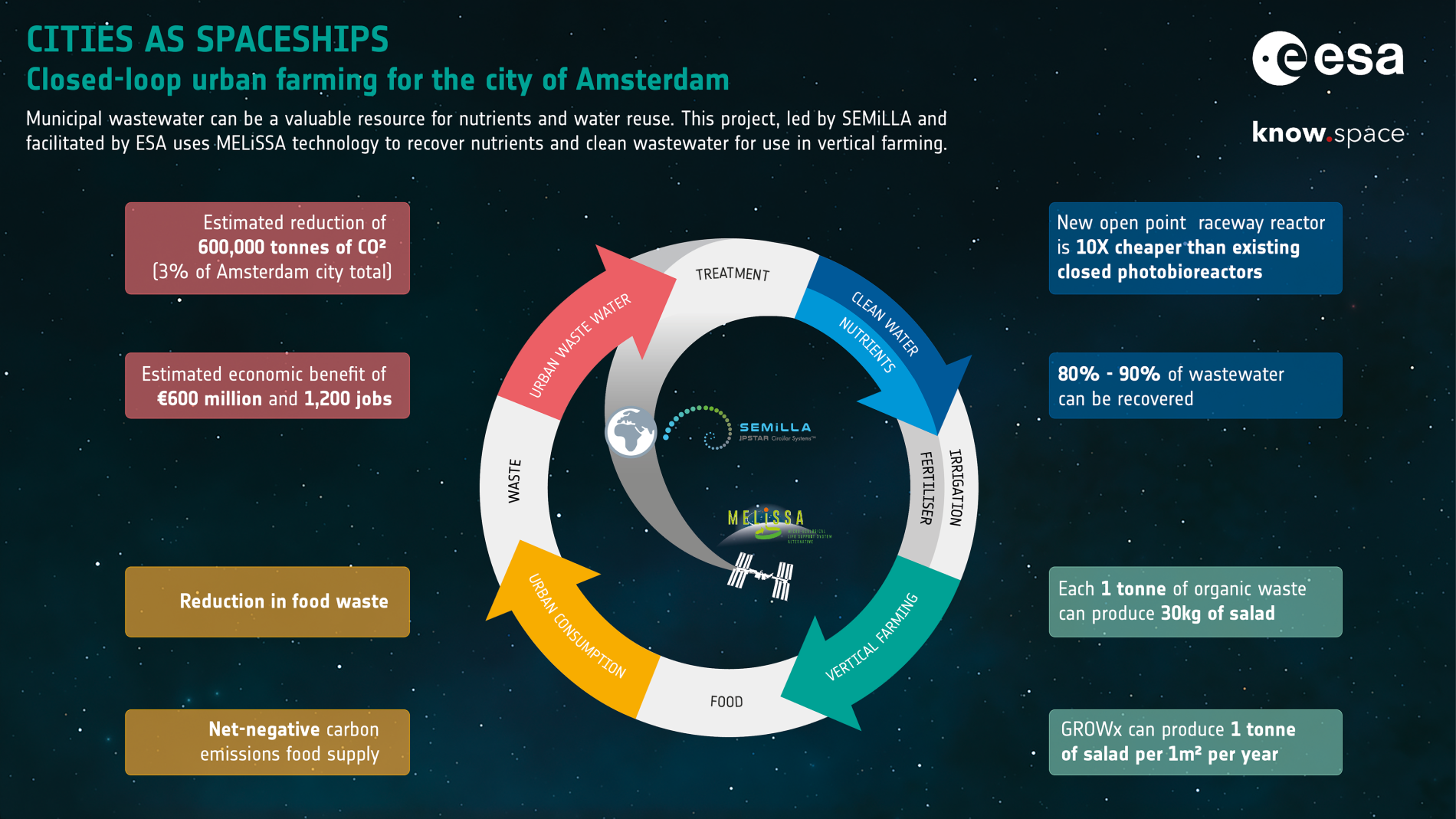
With more than 60% of the world population projected to live in urban areas by 2050, urban planning is becoming a technological challenge in which satellite data can play a fundamental role. Representatives from the cities of Milan and Baia Mare discussed how space technology can help urban planning on November 26, 2020 in a seminar organised by ESA’s Downstream Gateway department.
The seminar was presented by Donatella Ponziani, Head of the Downstream Gateway Office at ESA, and moderated by Javier Ventura-Traveset, Head of Galileo Navigation Science Office at ESA .
Andrea Aliscioni, Director of Integrated Water Service Division at MM Spa, presented the challenges of managing a complex sewage network. The aim is to prevent risks of surface collapsing or subsidence phenomena caused by the sewage network. In Milan, there are three inspection and detection methods: human inspection inside the conducts, dangerous and inefficient; IoT ground instruments, requiring thousands of sensors; satellite data from the Copernicus constellation, inexpensive and very effective.
Piero Pellizzaro, Chief Resilience Officer at Municipality of Milan, illustrated how climate data are taken from satellites to measure the temperature of ground in specific areas. Those data are valuable for several applications, for example in urban planning to decide which area needs more water or coverage. Another application is the mapping of the roofs of the city, to give back to the community how the roofs can be exploited.
Sorin Pop of of Municipality of Baia Mare presented the Spire Project, which has the aim of recovering polluted areas, and how it leverages on data from Earth Observation combined with field measurements to identify the areas of intervention.
Zoltan Bartalis, Earth Observation Application Engineer at ESA, illustrated the several ESA satellites currently in orbit: a first group for scientific research, a second group for Earth Observation (Copernicus satellites) and a third group for meteorology measurements, all providing free and open data. Satellite data applications range across several fields: transport and infrastructure management, risk mitigation and historical urbanisation tracking.
Beatrice Barresi, Downstream Business Applications Engineer at ESA, presented several applications of space technology to urban planning: Equant, an intelligent transport system that uses ground sensors combined with satellite systems for roads maintenance and traffic monitoring; Digital Twins, tools that can be used for descriptive and predictive purposes to discover how policies affect or would affect the environment; Urban Green, projects aimed at realising green buildings within cities with the help of data from space.
Please find in the following table the presentations of the event.
| Piero Pelizzaro – Chief Resilience Officer, Municipality of Milan | live (no presentation) | |
| Andrea Aliscioni – Director of Integrated Water Service Division, MM Spa, Municipality of Milan | Monitoring the health of Milan sewerage networks | |
| Sorin Pop – Spire Project, Municipality of Baia Mare | SPIRE | |
| Zoltan Bartalis – Earth Observation Application Engineer, ESA | Satellite Earth Observation and urban planning | |
| Beatrice Barresi – Downstream Business Applications Engineer, ESA | Space for green and sustainable infrastructure |
You can watch here the full recording of the event.